
Welcome to thatlinuxbox.com Wednesday, May 13 2026 @ 11:19 PM UTC
Trail Running in the Hocking Hills, Ohio
- Wednesday, December 26 2012 @ 02:55 PM UTC
- Contributed by: Dan Stoner
- Views: 14,100


On Christmas Day I ran from Old Man's Cave to Cedar Falls to Ash Cave along the Buckeye Trail in the Hocking Hills. It was a cold day (32 degrees), with lots of icicles hanging from the rock formations. The trail section between Old Man's Cave and Cedar Falls is technical with rocks, roots, and stone stairways to navigate. I was glad to have my Altra Superior trail running shoes. The section between Cedar Falls and Ash Cave is not technical but has some serious hills leading up to the fire tower. The fire tower is open for climbing, and after reaching the top there is a very nice 360 degree view of the surrounding Hocking Hills region.
I didn't carry a GPS so I'm not exactly sure how far I ran, but the round trip is somewhere between 10 and 12 miles. The Buckeye Trail is well-marked here, just "Follow the Blue Blazes...".
Pictures from the Old Man's Cave section:


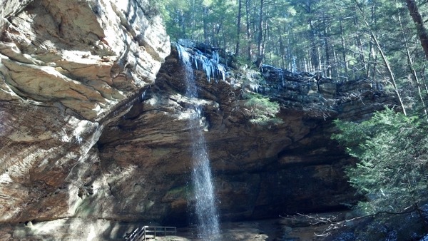
Pictures from the Cedar Falls section:


Picture from the Ash Cave section:
Here is a map excerpt that includes the Old Man's Cave section of the Buckeye Trail. The trail is maintained and supported by the Buckeye Trail Association and volunteers.

map image courtesy of the Internet.
There were very few people out early in the morning on Christmas Day so I mostly had the trails to myself. It was awesome! How did I miss out on these amazing trails during all of those years when I lived in Ohio?
I didn't carry a GPS so I'm not exactly sure how far I ran, but the round trip is somewhere between 10 and 12 miles. The Buckeye Trail is well-marked here, just "Follow the Blue Blazes...".
Pictures from the Old Man's Cave section:
Pictures from the Cedar Falls section:
Picture from the Ash Cave section:
Here is a map excerpt that includes the Old Man's Cave section of the Buckeye Trail. The trail is maintained and supported by the Buckeye Trail Association and volunteers.
map image courtesy of the Internet.
There were very few people out early in the morning on Christmas Day so I mostly had the trails to myself. It was awesome! How did I miss out on these amazing trails during all of those years when I lived in Ohio?
 GitHub


The following comments are owned by whomever posted them. This site is not responsible for what they say.